The Volga is a tributary of the Kama, and the Yenisei flows into the Angara: but why on the maps is everything the other way around
Everyone knows that the Angara flows into the Yenisei, and the Kama is the largest tributary of the Volga. But if you look at this issue from a scientific point of view, it turns out that this statement is not entirely true. Moreover, there are a fairly large number of rivers on our planet whose relationship with their tributaries does not always correspond to reality. A larger river often flows into a less full, or inferior to it in other respects. But due to the established historical tradition, no one is in a hurry to rename the Ob to the Irtysh or the Volga to the Kama.
How is it determined which river is the main one? Of course, in most cases this can be seen visually: the tributary, as a rule, has a smaller channel width and less full-flowing compared to the main river. But there are exceptions to this rule when rivers look equivalent. And in this case, scientists come to the rescue who can evaluate the river by its parameters, of which in our case the most important are the water discharge, the area of the basin, the order of the river, and the structural features of the river valley.
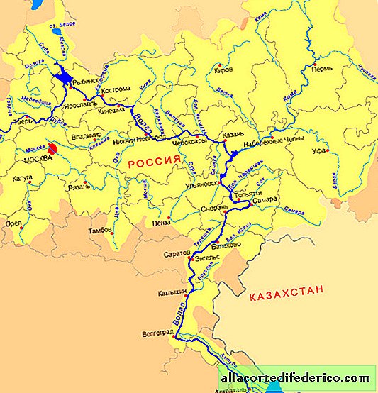 Volga river basin
Compare the Kama and Volga rivers. According to most hydrological parameters, it is Kama that is the main river, and the Volga acts as its major tributary. The Kama river valley is more ancient, and during the glaciation era it was the Kama river that flowed into the Caspian, while the Volga was a tributary of the Don River. And the modern lower course of the Volga River, according to most scientists, is a continuation of the river valley of the Kama River. If you look at the map, you can clearly see an unusual picture for the tributary and the main river: the Kama practically does not change its direction after its confluence with the Volga, while the Volga channel sharply turns 90 °, which is more typical of the tributaries.

If we compare in length and fullness at the time of the merger, then here Kama surpasses the Volga. The water discharge in Kama at the confluence of two rivers is 4300 m³ / s, and the water discharge in the Volga is only 3100 m³ / s. The length of the Kama at the time of the meeting is 2030 kilometers (excluding the construction of the reservoir, which reduced its length to 1882 kilometers), and the Volga just 1390 kilometers. Despite the obvious evidence of the superiority of Kama, no one is in a hurry to change the names and redo the maps: it happened historically, and there is little sense in renaming the river downstream. In addition, this will lead to a number of misunderstandings: the city of Volgograd will be on the Kama River, and all related facilities, such as the Volgograd Reservoir or the Volga-Don Canal, will also have to be renamed.
 The confluence of the Yenisei and the Angara: judging by this picture, it is not clear why the Angara is a tributary of the Yenisei, and not vice versa
An even stranger situation is with the Yenisei and Angara rivers. The hangar at the confluence with the Yenisei is longer and more full-flowing, and its water flow is 4,530 m³ / s, while the Yenisei has only 3,350 m³ / s. But it so happened that the development and study of Siberia went from west to east, therefore, the Angara flows into the Yenisei, and not vice versa.
 Ob River Basin
Things are a little different with the Ob River and its largest tributary, the Irtysh River. The length of the Irtysh is 4248 kilometers, and the length of the Ob from the source to the confluence of two rivers is only 3150 kilometers. The catchment area of the Irtysh is also larger than that of the Ob: 1640 thousand square meters. km against 1000 thousand square meters. km But due to the fact that the Irtysh most of the way flows through the arid steppes and its waters are taken in large volumes for irrigation and water supply of large cities, by the time of the confluence with the Ob, it is inferior to it in terms of water flow: 3,000 m³ / s - near Irtysh and 8,000 m³ / s at Ob.

North America also has its own "river injustice" - a pair of Mississippi-Missouri rivers. Missouri, the largest tributary of the Mississippi, is 3,767 kilometers, while the length of the Mississippi from the source to the point where the Missouri flows into it in St. Louis does not exceed 2,500 kilometers. Missouri also surpasses the Mississippi in its catchment area. But the Mississippi at the confluence of rivers is more full-flowing compared to Missouri and it is it that is considered the main river and the symbol of the United States.
Watch the video: Why all world maps are wrong (April 2024).


-
Pilot girl travels the world and shares celebrity photos on her Instagram
Meet this 30-year-old Mexican Alejandra Manriquez Perez. She is the co-pilot and owner of an Instagram account with tens of thousands of followers. And all this is due to the fact that she does not just fly around the world, but does it on a private luxury plane in the company of stars of the first magnitude. Even in her youth, a girl, moonlighting at the airport, dreamed of a profession associated with constant flights. ... -
-
-